Monday, October 19, 2009

Middle Cherry Creek

Good, Good, Good kayaking
Bad, Bad, Bad put in
Darcy on one of the many boulder garden drops on Middle Cherry
Don and I were hanging out in Groveland, CA waiting for Upper Cherry Creek to come in. We were about to head into West Cherry for a 2nd lap when we ran into some friends who had just finished a "new" run and were raving about it. Middle Cherry, they said, was not to be missed if there was still water in it. To be fair, they did warn us that we'd have to go through about 1 hour of hell hiking into the river, but that the whitewater was so good, it was more than sufficient payback. Well, they were right (somewhat).

Don enjoying some classic Middle Cherry whitewater
It was an hour of hell getting to the put in, but we were rewarded with one of the better day runs we did all summer in CA. The problem was, however, that hour of hell later turned into 3 weeks of hell when the massive cases of poison oak hit us.

Don during the first 300 yards of the hike--this part was great!

The hike started out innocent enough with a nice open meadow and a good vista of the confluence of Middle Cherry and Elanor Creek--our destination.

This is what our hike looked like for the better part of the hour and ten minutes it took us to reach the river.

But, that nice meadow all too quickly gave way to a hellishly thick layer of trees, bushes, and lots of poison oak that we ended up crawling through and over for just under an hour. Half the time Don and I couldn't even see each other even though we were never more than 20 feet apart. At one point during the hike I turned around to free my kayak from the tangle of bushes it was hung up in and noticed that there was a nice, oily poison oak leaf caressing my cheek.
Despite a thorough washing at the river, Don and I both came down with wicked cases of poison oak. It was my first experience with the stuff, and it really F-ing sucks!

Darcy on the first real rapid of the trip

At the time, though, we had no idea we'd soon be writhing in poison oak agony, and we were just happy to be at the river running 1 incredible rapid after another.

Darcy running a small waterfall in the first half of the run

Almost exactly half way through the run, there is a 40 foot drop that is rather intimidating, but goes pretty well if you don't mind taking a big hit (sorry, we don't have a photo of it). Also, if you are creative, there is a portage route on river right; but due to the massive amounts of poison oak here too and the sketchy nature of this portage and subsequent seal launch, I think I'd opt for just running the falls next time!


Don dropping the waterfall just below the little dam about 2/3 of the way down this run. Shortly after he landed this drop, the water began to rise...

Roughly 2/3 of the way down this run you'll come to a small dam where there is also a hike out option if necessary. Unbenounced to us, while we were down in the Middle Cherry Canyon, the dam keepers up in Cherry Lake had decided to start releasing water in anticipation of the hot days and snow melt to come. So, right about the time we got to this dam, we noticed that the water was rising.

Don running the drop just below the dam waterfall--this was the last we saw of our "put in flow"

Just seconds after Don landed this drop, the water doubled on us. We watched that big rock on river right in this photo, disappear. Then we decided we'd better get a move on since we had no idea just how big the river was going to get, nor did we know how much further we had to go until the take out.

The rapids below here were juicy and intimidating with the added flow, but they all went. We made our way downstream, scouting often, but made the take out just around 5pm. We got lucky as there were a couple of groups who put on behind us and ending up having to hike out at the dam.
Middle Cherry runs very infrequently as there are dams on both Middle Cherry and Elanor. But, if you happen to be there when somewhere in the neighborhood of 300-500 cfs are either spilling or being released, it's worth it. Just watch out for the poison oak!

Saturday, September 5, 2009

South Silver at really, really, really low water


Darcy (me) in the "Teacups" This was the best part of our low water run.

So there we were sitting in Coloma, CA sweltering in the 108 degree heat, and somewhat bored out of our minds. We had just finished our first lap down Upper Cherry Creek and were waiting for Bill to get back from France so we could go back in for round 2. We had heard that people were still doing South Silver so we headed up there one evening to beat the heat.


Here I am scouting from a unique low water vantage point.

We were very skeptical about the extremely low flow, but ran into 2 guys at the take out who had just done the run and claimed it was worthwhile, so we went to the put in.


Me trying to figure out how the hell to avoid contact with that rock at the bottom of the slide

I had only done South Silver once before and the water was relatively high then--because that's how those damn Beveridge brothers like it. During my first trip, we were all worried about getting worked in the hole at the bottom of Autobahn. Despite the speed we picked up on the slide, the hole was big enough to be a formidable obstacle to our downriver progress. This trip was quite the opposite. Don and I were worried about how to not hit the giant rock that makes the hole at high water! Well, we both hit it, but they were glancing blows and we were on our way.

Don, one of the random slides (at least I don't know the name for it).

Here's Don finding some deep water in Skyscraper.

Don entering Off Ramp.

Me bouncing my way down Off Ramp. I'm lucky my boat didn't break on this one!

So, I can't say that I recommend South Silver at these flows (hmmm, maybe it was 50cfs and that's probably a generous guess).
Unless you're really hot and bored, I'd give it a miss unless there's a bit more water. South Silver is, however, an awesome run at regular flows, so when you hear people saying it's a good medium level, go for it!
South Silver Logistics:
Coming soon--I have to ask Don because I can't remember how to get there other than driving up towards Ice House Reservoir from hwy 50.

Friday, August 14, 2009

Chawanakee Gorge

June 25th The Chawanakee Gorge on the San Joaquin River is an amazing stretch of whitewater, but it's very tricky to catch due to the dam upstream of it. If they had their way, the dam keepers would not let any water spill. Inevitably, however, the dam spills pretty regularly each spring giving the gorge flows of around 5,000-10,000 cfs--way too much for kayaking. An ideal kayaking range is 500-1500 (although 1500 would probably be pretty stout). While we were waiting for Upper Cherry to come in, we saw that the gauge was reading right around 700--perfect! The reading had gone from perfect to N/A many times in the past couple weeks so we were little scared that we would make the 6 hour drive down to the river only to find no water. But, we went and hoped. When we made it to the put in at 2pm, we found water!

The put in is a little tricky. After you paddle about 1/2 mile across a small reservoir, you get to the dam above Chawanakee Gorge. It's quite scary paddling right up to the brink of the dam to get out and portage down the steep right side of it. I'm not sure if it was something I ate, but I was feeling awfully sick at the dam. While I was busy dry-heaving, Don was scouting the best way to the river. At that moment I really wanted to hurl much more than I wanted to go kayaking, but I knew if we didn't go today, we might wake up tomorrow to find a try riverbed. So, in we dropped. We lowered boats and then used a fixed rope to get ourselves down to the river. Judging by the lack of kayak plastic anywhere, and the fact that the fixed rope was buried in a lot of mud, Don and I think we were lucky enough to be the first kayakers into the gorge this season.

Because we didn't end up getting to the actual river until around 3:30pm we were constantly pushing downriver as fast as possible. As a result, we didn't take too many photos. But, here is 1 of Don in the middle of a pretty cool series of rapids right in the middle of the run.

Darcy finishing one of the earlier rapids.
This run constantly has the feeling that you are going to get walled in (and in 2 short places you do, but the rapids are very runnable), but overall you can scout and portage everything at river level. Here I am enjoying some typical Chawanakee scenery.

Typical scenery in the gorge. There are 2-3 bigger drops on this section, but the overall character is what you see right here. It is a really quality section of whitewater if you are ever lucky enough to catch it with the proper amount of water.
Chawanakee Logistics:
This run is the Stanley/Holbeck guidebook. The road shuttle is about 1 hour each way, but there are good roads to the put in and take out.
Check http://www.dreamflows.com/ and there is a Chawanakee gauge (if it's working).


Saturday, August 8, 2009

Upper Cherry Creek

Trip 1: June 30th-July 2nd
Trip 2: July 6th-7th


Darcy running Cherry Bomb falls

Upper Cherry Creek was definitely one of the highlights of our summer California trip. We ended up doing 2 trips into UCC, one at somewhat high water and one at somewhat low water, but both were amazing experiences!

After the 10 mile hike in the "warm up slides" are both a welcome and an intimidating sight.


Don Beveridge in the 1st of the 5 "canyons" on Upper Cherry Creek.

This is the "Class IV Canyon," followed by "Cherry Bomb Gorge," then the "Waterfall Canyon," the 4th and 5th canyons I'm not sure of the names... The canyon just a little ways below the confluence with West Cherry we called "Kiwi in a Crack," but I believe some people call it "Red Rock Canyon," and then there is the "Last Canyon" that drops you into the giant log jam at Cherry Lake.

Bill Beveride dropping Cherry Bomb Falls.

Since it was my and Don's 2nd trip down UCC, we decided to just drop into Cherry Bomb Gorge without doing the long hike around to scout. We assured Bill that we remembered everything well enough to give him verbal beta for the canyon. So after a quick scout at the lip of the falls, Bill committed dropping the falls into Cherry Bomb Gorge.

The Gorge

Don running the Perfect 20 Footer.

In my opinion, it's a little higher than 20 feet!

Me (Darcy) on the same drop

Don in dropping into the "Waterfall Canyon"

Me in the Waterfall Canyon

Don on the same drop on our first trip--a little more water!

Bill B. Double Pothole

Don below Dead Bear, but still above the confluence with West Cherry

Darcy dropping into the last canyon

Upper Cherry Creek Logistics:
The Take Out: 2 options:
#1 the boat ramp at the far end of Cherry Lake. The paddle across the lake isn't too bad, it only takes 1 hour.
#2 you can park on the northeast end of the lake. Drive across the dam and take a left. Drive 2 or so miles and look for another left turn before the road you are on heads uphill. Follow this "unimproved" road down to its end. Park here. It's about a 20 minute hike from the lake to where you park. If it's your first time there, it's a good idea to hike down to the lake to scout the take out.
Put In: Cross the Cherry Lake dam, hang a left and drive up that road until it dead ends at your trailhead. Hike 10 miles over Styx pass and down to the river. There is really only 1 place you can take a wrong turn and it's signed so you should be alright if you pay attention. It's less than an hour into the hike you will come to a Y--you go left towards Styx Pass.
You need a wilderness permit for this one too, which you can either get at the Groveland Ranger Station or the Sonora Station. It's important to get one because the rangers have become more diligent in checking since this is becoming a more popular run each year. More people means more impact, so be sure you follow good wilderness principles. This year someone dragged their blue kayak in and left plastic over about 3/4 of the trail--not cool. If you can't carry your kayak 10 miles don't go. We also picked up tons of trash on our 2nd run down the river at the 2 campsites we used on the river. I ended up with 2 extra gatorade bottles and 4 powerbar wrappers. Let's try to keep our rivers clean and not give kayakers a bad name! Thanks.

Monday, July 27, 2009

Middle Kings River

July 20th-25th Don Beveridge and I got back from a season of guiding in Ecuador this winter and decided we would try for our 5th time to take the summer off from work and just go kayaking. We've been trying to save money for this for years, but a long string of injuries including broken ribs, a torn ACL, broken leg, and broken bank accounts have stopped us in the past. But this year things all fell into place and here it is July 27th, we haven't worked in months, and we have kayaked many a beautiful river. We've been so busy kayaking, in fact, that this is the first chance at blogging I've had. I plan to put up a full summer report, but I figure I'll start with the most recent trip and work my way back to May when it all started.

So, the most recent trip is the Middle Kings River. This one requires a bit of background information which I feel is best illustrated by a timeline:

July 5th: Bill Beveridge arrives home from France and Don and I have just finished with our first ever trip down Upper Cherry Creek. We tell Bill that he has to come with us for our 2nd trip because it's "just that good." We had high water our first trip so we knew we could get another one in before the river dropped out.

July 6th: Help Bill pack his boating stuff for an overnight trip, drive to Cherry Lake hike 2 hours and camp out.

July 7th: Finish hike in and paddle to just above Cherry Bomb Gorge

July 8th: Run Cherry Bomb (poor Bill had to run Cherry Bomb Gorge and Double Pothole without scouting, but we gave him great beta, and I think deep down he liked it). Then we finished the river and drove back to Coloma

July 9th: Bill unpacks from France, we put away creek boats and load up play boats

July 10th: Drive to Canada for Don and Bill's parents' 50th wedding anniversary (we are all very distraught because we see that the Middle Kings in almost good and we are certain we are going to miss it while in Canada)

July 11th, 12th, 13th: Surf Skookumchuck

July 13th, 14th, 15th: Enjoy family reunion and anniversary festivities in Egmont, BC

July 16th: Wake up early in Egmont, BC, check Dreamflows and find that, by some miracle, the Middle Kings is hovering in the 1300 range. So we get all excited, pack up the car and drive all night back to California.

July 17th: 11am arrive to Coloma, CA. We pack our creek boats and at 5pm start the long drive to the take out for the Middle Kings. We arrive at Pine Flat Reservoir around midnight and camp

July 18th: Wake up at 6am, finish the shuttle, and drive 8 hours over to Bishop to get to the put in. While driving we experience a big thunder and lightening storm followed by 10 minutes of intense downpour. We notice some smoke in the hills near Bishop. We stop at ranger station to get our permit where they tell us we can't go to South Lake Trailhead because lightening has struck and there is a fire--the road to our trailhead is closed until further notice...

Bishop fire squashing our hopes of the Middle Kings
Don is trying to sweet talk the cops into letting us up...it didn't work

But, alas, after 2 days of languishing in Bishop, CA thinking our marathon driving was for nothing, they let us up! (Well, they sort of let us up. We followed a group of cars that was being escorted up to retrive their vehicles from the trailhead and no one told us we couldn't go, so we took that as a green light). We called Shannon to have him check the flow for us one last time and he reported it was holding at between 1150-1250 which seemed sufficient. So on July 20th at high noon we started the hike in. Here Bill and I are enjoying some Bishop Pass scenery.

The hike in truly does SUCK, but the scenery is awesome.

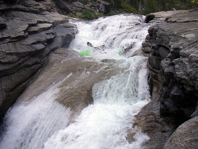
Bill on the first "real" rapid Day 1

Prior to my trip, the only photos I'd seen of the Middle Kings were of the classic big drops. While those rapids are very impressive, to me, the smaller, but very continuous rapids were the real killer on this trip. Especially in the Bottom 9 (but also in many other sections on the river) the Middle Kings' gradient is relentless. I can say that this is the most tiring river trip I've ever done! Enjoy some photos of the "little stuff."

Bill on our "breakfast rapid" right below our 2nd night's camp

Darcy day 2


Bill Beveridge somewhere on day 2

Here is Don leaving Tehipite Dome behind and about to drop into the hellish Bottom 9. This was my 31st birthday, and let me tell you, after 11 hours of paddling I was feeling my age:) I surely earned my crappy dehydrated meal that night!

Don in the Bottom 9


Me in the Bottom 9

We were all relieved to get to the Garlic Falls Section the next day. And, we were quite shocked at how great that section was. I'd never heard much about it, but it's got some really quality rapids in it and the pool drop character was such a relief after the Bottom 9.


And, perhaps the sweetest part of the trip--getting to the take out and finding that Don's Extreme Cold cooler and his expert packing skills had come through for us! We had icy cold PBRs even after the 2 extra days of waiting we had to do in Bishop--good work Don! It was our first beer in a week, we'd successfully completed the Middle Kings, no one had broken into our take out vehicle, and we were happy!


Middle Kings Logistics:
There are a few options for the Take Out on the Middle Kings. We parked our car at Zepher's whitewater camp because we figured that would be a fairly secure place to leave an unattended vehicle for a week. But, in doing this, it meant that we had to also paddle the Banzai section, which at good Middle Kings flows is somewhat tedious (there is a lot of flatwater). There are directions in the CA guidebook for this take out, and it's about 1 hour east of Fresno. If you aren't too concerned about your car, you can drive up past the Zepher camp, cross the bridge and continue up river right for probably 4-5 miles and there are lots of fishing access points where you can park your car. If you park here you can avoid paddling the Banzai section. A 3rd option is to hike out at the confluence of the Middle and South Kings (at Yucca Point). This is not recommended as I hear the hike really sucks, AND you miss the Garlic Falls sections which really is pretty fun.
Put In: Drive your ass all the way through Yosemite and over the Sierras and down to Bishop--this took us just over 8 hours. VERY IMPORTANT: stop at the Bishop ranger station and get a wilderness permit. People have been turned back for not having this permit, so get one! Drive out West Line street in downtown Bishop to South Lake Trailhead. Hike up over Bishop Pass, through Dusy Basin and down into LeConte Canyon (13 miles), find the river and rejoice! We took 2 days for the hike in and then 4 days to paddle the river. It was a pretty good schedule, but I might allow for one more day on the river next time as we did put in pretty long days.